Boundary Surveyors: Working with Utility Locators for Accurate Results
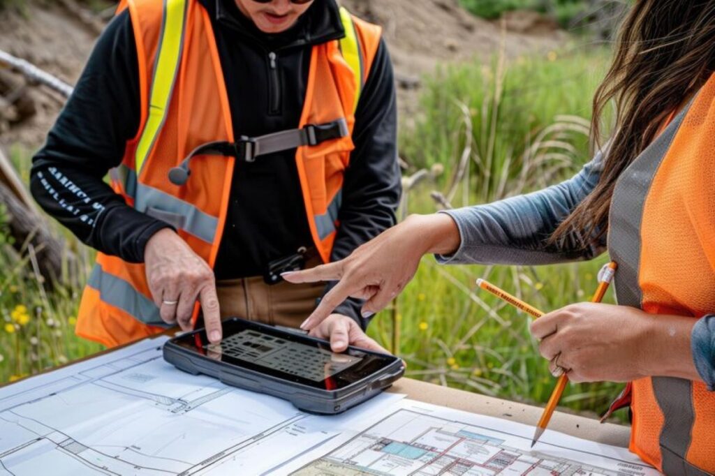
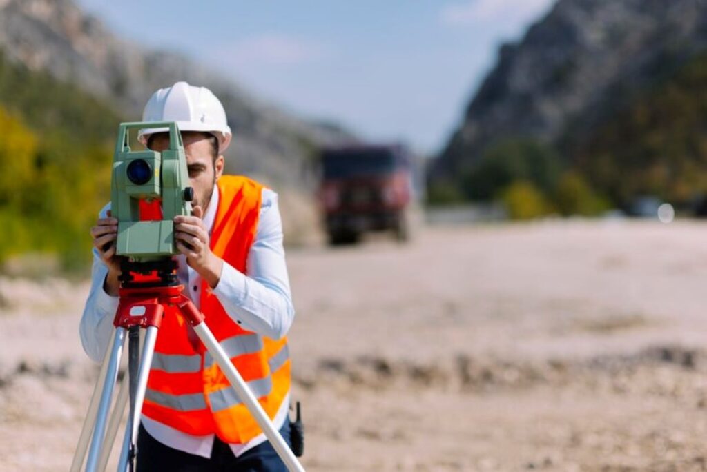
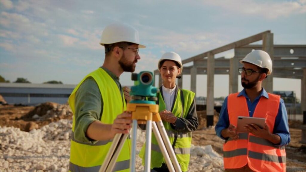
Land development and construction projects require a clear understanding of both surface boundaries and underground infrastructure. Boundary surveyors are experts who determine and document property lines, ensuring legal compliance and accurate property dimensions. They work closely with utility locators – specialists who identify and map underground utilities such as water pipes, electrical cables, and gas lines. The combination of boundary surveying and utility location offers a thorough site assessment that is invaluable for: A successful partnership between boundary surveyors and utility locators provides detailed, accurate site documentation. This collaboration reduces the risk of expensive mistakes, potential damage to existing infrastructure, and safety hazards during construction or development projects. The cooperation between these two specialised fields has become essential in modern construction and development. Their combined knowledge gives stakeholders crucial information for making informed decisions and executing projects. End-to-End Services Provided by Registered Surveyors and Utility Locators Registered surveyors and utility locators deliver comprehensive services essential for successful construction and development projects. These professionals work across multiple sectors, providing specialised expertise in their respective fields. Registered Surveyors’ Services: Utility Locating Services: These services play a critical role in: The property, construction, and infrastructure sectors rely heavily on these professional services for project success. Accurate data from both surveyors and utility locators enables informed decision-making throughout project lifecycles. Their expertise helps prevent costly delays, reduces potential damage to existing infrastructure, and ensures compliance with regulatory requirements. The integration of these services creates a robust foundation for development projects, supporting everything from initial planning to final construction stages. This comprehensive approach helps maintain project timelines while safeguarding both assets and personnel involved in construction activities. Wumara Group: Indigenous Procurement Consulting and Surveying Services Wumara Group is a leading provider of professional consulting services in New South Wales and Queensland. The company offers a wide range of services, including: The organisation has built a solid reputation through successful collaborations with prominent clients in the telecommunications sector, including CI International, City of Sydney Council, Telstra, and NBN. A notable achievement includes supporting School Infrastructure NSW (SINSW) on critical state government initiatives. Innovative Subsurface Utility Locating Wumara Group’s approach to subsurface utility locating combines advanced technology with skilled professionals to deliver accurate results. Their surveying teams use state-of-the-art equipment and techniques to ensure precise identification and mapping of underground assets. Commitment to Client Satisfaction Client satisfaction is a core value at Wumara Group, demonstrated by consistently positive feedback regarding: The combination of technical expertise and cultural understanding makes Wumara Group an invaluable partner for organisations seeking comprehensive surveying and utility locating services while promoting Indigenous business engagement. Their expertise also extends into areas such as site investigation management, where they ensure thorough oversight and coordination for all projects. Enhanced Safety Measures Through Professional Utility Locating Services Professional utility locating services play a crucial role in maintaining safety standards during construction projects. These services help prevent potentially catastrophic accidents and costly damages through precise identification of underground infrastructure. Key Safety Benefits: The implementation of professional utility locating services creates multiple layers of safety: Professional utility locators use non-invasive methods to detect and mark underground assets, creating a safer work environment for all stakeholders. Their expertise helps construction teams maintain compliance with safety regulations while protecting valuable infrastructure and human life. The integration of these safety measures with boundary surveying creates a comprehensive approach to project safety, ensuring all underground utilities are accurately documented and protected throughout construction activities. Advanced Techniques Used by Utility Locators for Accurate Detection Modern utility location requires precision and reliability. Professional utility locators use advanced technology and methods to ensure accurate detection of underground infrastructure. Ground Penetrating Radar (GPR) Ground Penetrating Radar (GPR) is a non-destructive geophysical method that uses high-frequency radio waves to penetrate the ground and create images of the subsurface. It is particularly effective in locating non-metallic utilities such as plastic pipes, fibre optic cables, and drainage systems. GPR can also detect variations in soil conditions, which may indicate the presence of buried structures or utilities. Electromagnetic Locators Electromagnetic locators are commonly used to trace metallic utilities such as copper or steel pipes and power cables. These devices work by generating an electromagnetic field that induces a current in the buried metal object. The locator then detects the resulting magnetic field and determines the location and depth of the utility. Electromagnetic locators are especially useful for locating water pipes, as they can differentiate between different types of signals based on their characteristics. GPS Integration Global Positioning System (GPS) technology plays a crucial role in accurately mapping utility locations. By combining GPR or electromagnetic data with GPS coordinates, utility locators can achieve centimetre-level accuracy in their surveys. This information is invaluable for creating digital records of underground infrastructure, facilitating future maintenance activities, and supporting excavation planning. These advanced detection methods work together to create comprehensive maps of underground utilities. By integrating multiple technologies, utility locators can verify their findings and cross-reference data from different sources. This approach minimises the risk of overlooking or misidentifying utilities, ensuring a more reliable assessment of the subsurface environment. Professional locators understand the importance of regular calibration and maintenance for these tools. They follow manufacturer guidelines and industry best practices to ensure optimal performance in various environmental conditions. Whether it’s rocky terrain, wet soils, or urban areas with complex underground networks, skilled locators adapt their techniques accordingly to deliver accurate results. The Role of Boundary Surveyors in Integrating Data from Utility Locators into Detailed Maps Boundary surveyors are essential in creating detailed property maps by combining utility location data with traditional surveying measurements. This complex process requires expertise in both interpreting data and using mapping technologies. The integration process involves: Professional surveyors use specialised software to merge multiple data sources into a single, accurate representation. These detailed maps serve as essential tools for: The accuracy of these integrated maps depends on precise coordination between field measurements and utility location data. Surveyors employ rigorous quality control measures to verify data alignment and spatial accuracy, ensuring the
Boundary Surveyors: Working with Utility Locators for Accurate Results Read More »